During the Bataan Memorial Death March, you will experience miles & miles of high desert. Virtual marchers will NOT be able to march on White Sands Missile Range! Learn more about the course below.
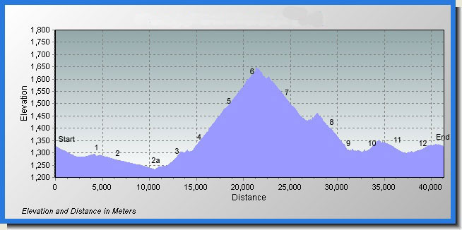
From the start line (blue star at the south end of the map), the routes go counterclockwise. They are numerically-marked (1-12) blue drops indicate the water points. The red stars indicate medical stations.
The 14.2-mile course is essentially the lower portion of the 26.2 mile course.
On the 26.2-mile course, the route proceeds northwest from Water Point 4/8, circling a small mountain known as Mineral Hill. Returning to Water Station 4/8, marchers travel south along the paved road covered earlier in the route. The course then veers west along dirt and sand trails, coming up the backside of the White Sands community and returning to the finish line.
The area known as the “Sand Pit,” featuring deep sand, comes after Water Station 9. But, be aware, the dirt trails elsewhere along the route can be sandy and dusty as well. This is particularly true of the stretch between Water Station 1 and Water Station 3.
“I’ve done 17 marathons – this was unreal. I wasn’t prepared for the sand.”
“I was shocked as to how difficult walking 26.2 miles could be. I’ve been on a lot of forced marches but none were harder than this.”
“I wasn’t prepared for all the loose sand – many miles of this and a lot of it uphill.”
“Training for this course like a regular marathon doesn’t quite do the trick. I should have done a lot of hiking, hills, rough terrain type training.”